Bethanien (North Caucasus)
Bethanien was founded in 1852. It is located just east of Pyatigorsk, and today is part of the metropolitan area of Pyatigorsk.
There were also Mennonites and colonists from Riebensdorf who settled in Bethanien.
The former German colony of Bethanien is known today as Konstantinovskaya.
The following Volga German families settled in Bethanien:
Ament
Altbach
Bäcker
Batzel
Boger from Riebensdorf
Bonwetsch
Brenning
Dilk
Flach
Goss
Hoffärber
Herdt
Heinrich
Henninger (?)
Hubert
Haupt
Hohnstein
Edel (Ettel)
Enders
Engelhard
Eichhorn
Juninger
Kindsvater
Koch
Kowatchs
Kipke
Lutz (?)
Leitner
Michel
Miller
Minz
Moor
Nikolaisen
Phillipi
Rau
Rothermel
Reichert
Ruppel
Rusch
Schilling
Schiro
Schmalz
Schneider
Schumann
Steinwand (Steinwein?)
Stürtz
Tempel
Tietz
Trippel
Vogt
Wagner
Weber
Weismuth
Welck
Windecker from Beideck
Zellmer
Zimmer
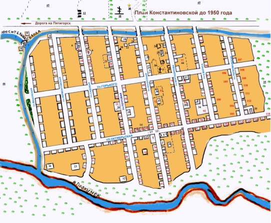
Map of Konstantinovskaya (1950).
Source: Sharon Baker.Legend (public buildings/spaces):
1. Lutheran Church (church), in the 20s of the XX century. - club.
2. Community council (until 1928), collective farm board ?? Frisch ans Werk ?? (until 1942), during the occupation - the German commandant's office. After the war, the office of the state farm No. 6, an elementary school, a savings bank.
3. Pastor's house (until 1928), school.
4. Parish 3-grade school (up to the 20s of the XX century)
3, 4, 39, 40. School (up to 1974).
5. The old pre-revolutionary cemetery.
6. Clays used to make building materials (adobe).
7. Irrigation system.
8. Konstantinovskaya HPP.
9. Office of the hydroelectric power station.
10. The drainage drip of the hydroelectric power station, dug in 1942 by hand
11. Melitsa, later a slaughterhouse.
12. Leather factory
13. Central square.
14. Community barn.
15. The old cemetery.
16. Burial place of victims of the civil war.
17. Burial place of an unknown pilot who was shot in 1942.
18. Water mill.
19. Horse yard, later a hostel for student agricultural brigades.
20. Mail, radio center.
21. Field brigade.
22. Bath.
23. Commodity store. Canteen. Barber.
24. Brigade №1. Construction shop, wine pretreatment station.
25. Ovens for drying fruits.
26. Mill for the preparation of feed.
27. Point of procurement and processing of agricultural products
28. Outpatient clinic (until 1957).
29. Rural hospital (from 1957 to 1980) - From 1984 to 1998 - music school.
30. Stadium.
31. Garage, mechanical workshops.
32. Board of the state farm ?? Goryachevodsky ??.
33. Veterinarian.
34. Brigade No. 2.
35. Ogorodnaya brigade and its land plot.
36. Kindergarten (from 1953 to 1978),
37. Nursery.
38. Collective farm kindergarten (until 1942).
39. Kindergarten (until 1953).
40. Kindergarten (until 1978).
41. Commodity store.
42. Pits for silage preparation.
43. Pigsty (until 1942).
44. Pigsty after the war.
45. Land holdings of the economy.
46. Ancillary economy of the Ministry of Internal Affairs.
47. Floodplain of the Podkumok river and forest.Legend (homes):
1. Gerter Eduard
2. Alexander Jwanow. (Familienname unbekannt)
3. Zerbert Theodor
4. Brehning Eduard
5. Alfred (Familienname unbekannt)
6. Schneider Emil
7. Rebachin?
8. Dilck
9. Korotkj (eng.)
10. Koch
11. Ruppel
12. Pisarenko
13. Metzger
14. Gerter Konrad Fried.
15. Miller Taisija
16. Polina (Familienname unbekannt)
17. Schumann
18. Rein
19. Krasnowi (Russian)
20. Kuhstall
21. Herdt
22. Holstein Julias
23. Post
24. Brehning Otto
25. Amendt Theodor David.
26. Klehmann & Brehning
27. Brigade No.3
28. Windecker, Konrad
29. Minz Peter
30. Gies Wilhelm (und auch Gebells)
31. Amendt Eduard
32. Gies Wilhelm
33. Baude
34. Windecker, Konrad
35. Jegorow (Russian)
36. Ettel Otto
37. Schmidt Otto
38. Lawrentschuk (Russian)
39. Ettel Theodor Christoph.?
40. Kolchos Sthal
42. Lisenko & Lugowie (Russian)
43. Schneider
44. Pferdestall
45. Gies Johannes
46. Schmalz Mina
47. Piskunow (Russia)
48. Miller Maria
49. Kinder garten
50. Miller
51. Kantine (Stolowaja)
52. Budde (Magazin)
53. Brehning Maria
54. Gies Albert & Olga
55. Kühn
56. Pastor's House
57. Hungers?
58. Kowatsch Karl
59. Miller Maria
60. Brehning Eduard & Maria (nee Rebachin?)
61. Day Care
62. Jurenkow (Russian)
63. Stoffel
64. Brehning Johannes & Erna (nee Gies)
65. Enders Jakob & Ella (später Magazin?)
66. Weber Heinrich
67. Borisenko (russ.)
68. Schneider Julias
69. Kraft Lea
70. Schehnberg
71. Kowatsch Mina
72. Gies & Preiss
73. Zellmer Julija
74. Toufelsin (Russian?)
75. Brehning Heinrich
76. Zimmer Marta
77. Schweine sthal
78. Einlegehof (Gemüse)
79. Ruppel
80. Deew (Russian)
81. Zimmer Jakob
82. Saniterpunkt
83. Scheinmann
84. Patzel Ludwig
85. Schäfer
86. Weber Friedrich (Bruder vom Weber H.)
87. Wartengin (Lehrer)
88. Schtoffel
89. Miller W.?
90. Latischew (Russian)
91. Schneider Mina
92. Pferdestall
93. Gies Jakob
94. Eichhorn Elsa
95. Fogelsthal
96. Haus der Geburt
97. Kindsfater Heinrich
98. Enders Eduard und Adelina
99. Weißmuth Otto
100. Leitner Felix & Marta (nee Gies)
101. Kolrigchos (Russian? )
102. Schäfer David & Rosa
103. Pivis Alexander
104. Minz Marta
105. Minz F.
106. Lieder Georg & Rusch (wahrscheinlich Schwiegersohn?)
107. Klehmann Ella (nee Gies)
108. Herdt
109. Heinrich Johannes
110. Reichert Heinrich Emmanuil.?
111. Hoffmann
112. Schilling Milda
113. Enders Julias
114. Heinrich Abraham (Bruder vom Johannes)
115. Hoffmann Konrad
116. Fischer (veternarian)
117. Fers
118. Borisenko (Russian)