Sewald
Sewald was founded on 20 August 1767 by colonists who had been recruited by Baron de Boffe. These colonists came from the Pfalz, Mainz, and Darmstadt regions of present-day Germany. It was named after Karl Sewald, the first group leader of the colony.
The German residents of Sewald were deported on 17 September 1741. They were taken by wagon to the railway station in the Russian village of Medvyeditskij (south of Hussenbach) where a train took them north to Samara and from there to the Omsk Region of Siberia. They spent two weeks on the train and one week on barges going up a river to their final Siberian destination.
In the 1960s, all the inhabitants of the former colony of Sewald were relocated to the former colony of Dietel, and the entire village was raised. Today, nothing remains of the former Volga German colony of Sewald. From satellite images, it is possible to see the layout of the former streets.
The colonists who settled Sewald were of the Roman Catholic faith practice. The congregation of Sewald belonged first to the parish of Schuck, later to the parish of Rothammel. It then became an independent parish.
The first church structure in the colony was built of wood in 1807. A new church building was constructed in 1839. Today, nothing remains of this building.
The Sewald Parish was served by the following priests:
- Adam Gareis
- Johannes Fuchs
- Martin Fix (1928)
|
Year
|
Households
|
Population
|
||
|---|---|---|---|---|
|
Total
|
Male
|
Female
|
||
| 1767 |
41
|
142
|
80
|
62
|
| 1769 |
39
|
134
|
68
|
66
|
| 1773 |
39
|
186
|
107
|
79
|
| 1788 |
38
|
229
|
126
|
103
|
| 1798 |
36
|
235
|
120
|
115
|
| 1816 |
42
|
339
|
174
|
165
|
| 1834 |
77
|
596
|
298
|
298
|
| 1850 |
78
|
901
|
430
|
471
|
| 1857 |
94
|
1,020
|
530
|
490
|
| 1859 |
98
|
1,081
|
549
|
532
|
| 1883 |
|
1,118
|
|
|
| 1886 |
163
|
1,062
|
547
|
515
|
| 1891 |
140
|
1,412
|
715
|
697
|
| 1894 |
|
1,506
|
765
|
741
|
| 1897 |
|
1,221*
|
607
|
614
|
| 1905 |
|
1,506
|
|
|
| 1911 |
|
2,002
|
|
|
| 1920 |
|
1,577
|
|
|
| 1922 |
|
1,766
|
|
|
| 1926** |
251
|
1,519
|
734
|
785
|
| 1931 |
|
1,669
|
|
|
*Of whom 1,212 were German.
**Of whom 1,516 were German (250 households: 732 male & 784 female).
- Seewald (wolgadeutsche.net) [in Russian]
- Beratz, Gottieb. The German colonies on the Lower Volga, their origin and early development: a memorial for the 150th anniversary of the arrival of the first German settlers on the Volga, 29 June 1764. Translated by Adam Giesinger (Lincoln, NE: American Historical Society of Germans from Russia, 1991): 353.
- Mink, A.N. Historical and Geographical Dictionary of the Saratov Province [in Russian] (Saratov, Russia, 1898): 118-120. (Online)
- Orlov, Gregorii. Report of Conditions of Settlements on the Volga to Catherine II, 14 February 1769.
- Pallas, P.S. Reise durch verschiedene Provinzen des Russischen Reichs. Theil 3,2, Reise aus Sibirien zurueck an die Wolga im 1773sten Jahr (St. Petersburg: Kaiserl. Academie der Wissenschaften, 1776): 622.
- Pleve, Igor. Einwanderung in das Wolgagebiet, 1764-1767 Band 4 (Göttingen: Der Göttinger Arbeitskreis, 2008): 11, 167-176.
- Pleve, Igor R. The German Colonies on the Volga: The Second Half of the Eighteenth Century, translated by Richard Rye (Lincoln, NE: American Historical Society of Germans from Russia, 2001): 313.
- Preliminary Results of the Soviet Census of 1926 on the Volga German Autonomous Soviet Socialist Republic (Pokrovsk, 1927): 28-83.
- Schnurr, Joseph, Die Kirchen und das Religiöse Leben der Russlanddeutschen - Katholischer Teil (Stuttgart: Selbstverlag Joseph Schnurr, 1980): 251.
- "Settlements in the 1897 Census." Journal of the American Historical Society of Germans from Russia (Winter, 1990): 18.

Map showing Sewald (1935).
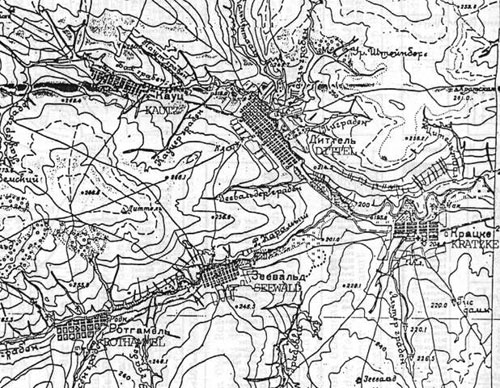
Map showing Dietel, Kautz, Kratzke, Rothammel and Sewald.
Comments
Please login or register to post comments.