Merkel was established on 28 August 1766 by colonists fom the Baden and Dresden regions of present-day Germany who had been recruited by Baron de Boffe. It is located along the Makarovka Creek where it joins the Karamysh River.
Merkel was named after Johann Georg Merkel, the first mayor (Vorsteher) of the colony. In an edict dated 26 February 1768, Merkel was given the official Russian name of Makarovka. According to Christian August Tornow, the colony was called Beckmann during the first couple of years after it was founded.
At the 8th Revision in 1834, the colony was allocated 15 desyatina per male inhabitant for a total of 2,340 desyatina. By the 10th Revision in 1857, this allotment measured out to only 4.5 desyatina per male inhabitant.
According to the information of the Central Statistical Committee in 1859, the colony there were a Lutheran church, a school, a mill. All were German Lutherans except for one Catholic, one Baptist, and one Reformed.
According to Minkh, between 1861 and 1879, 224 colonists moved to Friedenfeld, in the Novouzensk District, Samara Province. In 1876, 6 colonists and in 1877, 1 additional colonist immigrated to America. In 1886 another 2 families received passports and immigrated.
As of 1886, there were 134 habitable houses, of which 58 were built of rock and 75 of wood. Of them, 64 had wood-shingled roofs and 64 had thatch. There were 5 industrial businesses, and 1 saloon. The colony inventory includes 159 plows, 1 wooden plow, 36 winnowing machines, 1 threshing machine, 605 horses, 130 oxen, 726 cows and calves, 1,105 sheep, 500 pigs, and 300 goats. The land allotment of good soil was 3,332.5 desyatina, of which 2,503 desyatina is cultivated. The poor land amounted to 676 desyatina, for a total of 4,008.5 desyatina. Of this total, 2,188½ desyatina of good land and 591¼ of poor land is located near the colony, and 528¼ desyatina of good land and 18¼ of poor land is located 12 versts away. Pasture located west of the colony amounts to 200 desyatina.
There is a parish German school that as existed since the establishment of the colony. There is also a government school. There are 135 habitable structures made of wood, native stone, and brink. Most are covered with thatched roofs. Most inhabitants are farmers, but 100 people are employed in the sarpinka (textile) factory.
After the establishment of the worker’s commune system in October 1918, Merkel was placed under the jurisdiction of the Kamyenski Rural Council in the Balzer Kanton of the Volgograd Province. In 1926, the Village Soviet system was set up, and with the establishment of the Volga German Autonomous Republic on 1 January 1935, Merkel became part of the Frank Kanton. With the liquidation of the Volga German Autonomous Republic in 1941, Merkel became known as Makarovka, in the Zhirnovsk Region of the Volgograd Province.
Today, what little remains of the former colony of Merkel is known as Makarovka.
The congregation in Merkel belonged to the Dietel parish, later becoming an indepedent parish. A Lutheran Church building, built of wood with wood shingles, was constructed there 1826. Today, nothing remains of this building.
|
Year
|
Households
|
Population
|
||
|---|---|---|---|---|
|
Total
|
Male
|
Female
|
||
| 1767 |
|
110
|
|
|
| 1769 |
30
|
115
|
68
|
47
|
| 1773 |
36
|
141
|
83
|
58
|
| 1788 |
26
|
166
|
88
|
78
|
| 1798 |
30
|
213
|
117
|
96
|
| 1816 |
41
|
361
|
184
|
177
|
| 1834 |
83
|
606
|
327
|
279
|
| 1850 |
92
|
1,010
|
527
|
483
|
| 1857 |
110
|
1,199
|
626
|
573
|
| 1859 |
106
|
1,236
|
651
|
585
|
| 1886* |
138
|
1,176
|
583
|
593
|
| 1891 |
186
|
1,700
|
858
|
842
|
| 1894 |
135
|
1,785
|
898
|
887
|
| 1897 |
|
1,208**
|
591
|
617
|
| 1904 |
|
2,137
|
|
|
| 1910 |
|
2,422
|
|
|
| 1912 |
|
2,458
|
|
|
| 1920 |
186***
|
1,301
|
|
|
| 1922 |
|
1,212
|
|
|
| 1926**** |
245
|
1,437
|
714
|
723
|
| 1931 |
|
1,664
|
|
|
*Not including 82 absent families and another 8 families (38 individuals) who live outside the colony. In total, there are 315 male and 326 female colonists who no longer live in the colony.
**Of whom 1,195 were German.
***Of which 185 households were German.
****Of these 243 households were German, 1,435 people (712 male and 723 female).
Merkel (wolgadeutsche.net) in Russian
Merkel (Michael Frank)
Merkel Colony (1766-1941) (Margheim)
- Beratz, Gottieb. The German colonies on the Lower Volga, their origin and early development: a memorial for the 150th anniversary of the arrival of the first German settlers on the Volga, 29 June 1764. Translated by Adam Giesinger (Lincoln, NE: American Historical Society of Germans from Russia, 1991): 351.
- Diesendorf, V.F. Die Deutschen Russlands : Siedlungen und Siedlungsgebiete : Lexicon. Moscow, 2006.
- Dietz, Jacob E. History of the Volga German Colonists (Lincoln, NE: American Historical Society of Germans from Russia, 2005).
- Erbes, Johannes. Deutsche Volkszeitung (23 August 1906).
- Klaus, A.A. Our Colonies (Saint Petersburg, Russia, 1869): 48-49.
- List of the Populated Places of the Samara Province (Samara, Russia, 1910): 60.
- Minkh, A.N. Historical-Geographical Dictionary of the Saratov Province (Saratov, 1901): 602-605.
- Orlov, Gregorii. Report of Conditions of Settlements on the Volga to Catherine II, 14 February 1769.
- Pallas, P.S. Reise durch verschiedene Provinzen des Russischen Reichs. Theil 3,2, Reise aus Sibirien zurueck an die Wolga im 1773sten Jahr (St. Petersburg: Kaiserl. Academie der Wissenschaften, 1776): 622.
- Pleve, Igor. Einwanderung in das Wolgagebiet, 1764-1767 Band 3 (Göttingen: Der Göttinger Arbeitskreis, 2005): 119-129.
- Preliminary Results of the Soviet Census of 1926 on the Volga German Autonomous Soviet Socialist Republic (Pokrovsk, 1927): 28-83.
- "Settlements in the 1897 Census." Journal of the American Historical Society of Germans from Russia (Winter, 1990): 18.
1767 Census of Merkel
1798 Census of Merkel
1834 Census of Merkel
1857 Census of Merkel
50.883333, 45.287167
Migrated From
Immigration Locations
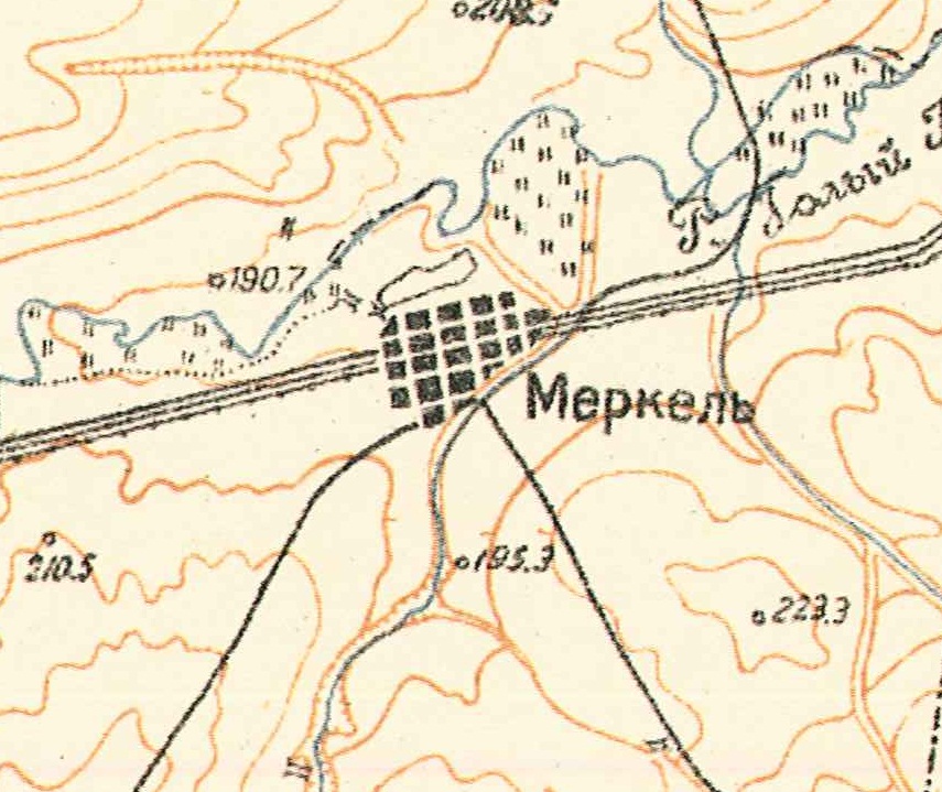
Map showing Merkel (1935).

Merkel bell tower, city hall, and school taken by Alexander Bauer in 1927.
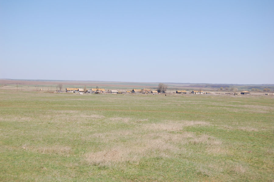
Panorama of Merkel (2009).
Source: Georgi Spach.