Holstein was founded on 26 May 1765 by the Government as a Lutheran colony. It is located on the banks of the Galka River.
Until 1768, the colony was called Kuxhausen.
Today, what remains of the former colony of Holstein is known as Verkhnyaya Kulalinka.
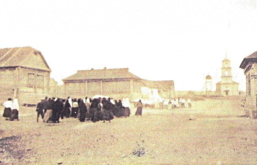
The congregation in Holstein was part of the Galka parish. The Lutheran church building in Holstein was built of wood in 1830.
In 1933, the bell tower was torn down, and by 1956 there was nothing remaining of the church. During the Soviet era, a monument to the Red Army was placed where the church used to be.
The congregation in Holstein was served by the following pastors:
- ?-1774 Pastor Bergstrom
- 1774-1778 Johann Kaspar Brauns
- 1782-1788 Jakob Alexander Topelius
- 1792-1794 Mag. Johann Dorn
- 1796-1804 Philipp Jakob Heimer
|
Year
|
Households
|
Population
|
||
|---|---|---|---|---|
|
Total
|
Male
|
Female
|
||
| 1767 |
45
|
335
|
|
|
| 1769 |
45
|
190
|
105
|
85
|
| 1773 |
43
|
202
|
114
|
88
|
| 1788 |
43
|
283
|
145
|
138
|
| 1798 |
50
|
354
|
168
|
186
|
| 1816 |
70
|
471
|
245
|
226
|
| 1834 |
101
|
928
|
488
|
440
|
| 1850 |
141
|
1,347
|
690
|
657
|
| 1857 |
127
|
1,404
|
715
|
689
|
| 1859 |
119
|
1,419
|
719
|
700
|
| 1886 |
174
|
1,402
|
719
|
683
|
| 1891 |
160
|
1,836
|
935
|
901
|
| 1894 |
162
|
2,086
|
1,074
|
1,012
|
| 1897 |
|
1,495*
|
744
|
751
|
| 1904 |
|
2,432
|
|
|
| 1911 |
|
2,548
|
|
|
| 1920 |
247**
|
1,528
|
|
|
| 1922 |
|
1,083
|
|
|
| 1923 |
|
1,186
|
|
|
| 1926*** |
256
|
1,360
|
665
|
695
|
| 1931 |
|
1,477****
|
|
|
*Of whom 1,444 were German.
**Of which 242 households were German.
***Of whom 1,334 were German (253 households: 653 male & 681 female).
****Of whom 1,472 were German.
- Beratz, Gottieb. The German colonies on the Lower Volga, their origin and early development: a memorial for the 150th anniversary of the arrival of the first German settlers on the Volga, 29 June 1764. Translated by Adam Giesinger (Lincoln, NE: American Historical Society of Germans from Russia, 1991): 350.
- Diesendorf, V.F. Die Deutschen Russlands : Siedlungen und Siedlungsgebiete : Lexicon. Moscow, 2006.
- Erbes, Johannes. Deutsche Volkszeitung (23 August 1906).
- Mink, A.N. Historical and Geographical Dictionary of the Saratov Province [in Russian] (Saratov, Russia, 1898): 549-551.
- Pallas, P.S. Reise durch verschiedene Provinzen des Russischen Reichs. Theil 3,2, Reise aus Sibirien zurueck an die Wolga im 1773sten Jahr (St. Petersburg: Kaiserl. Academie der Wissenschaften, 1776): 621.
- Preliminary Results of the Soviet Census of 1926 on the Volga German Autonomous Soviet Socialist Republic (Pokrovsk, 1927): 28-83.
- Report of Conditions of Settlements on the Volga to Catherine II by Count Orlov, 14 February 1769.
- "Settlements in the 1897 Census." Journal of the American Historical Society of Germans from Russia (Winter, 1990): 18.
50.4195, 45.698333
Migrated From
Immigration Locations

Map showing Holstein (1935).

Street scene in Holstein (August 1929). The church and accompanying bell tower can be seen at the far end of the street.
Source: wolgadeutsche.net