Huck was founded on 1 July 1767 by 79 colonist families recruited by Catherine the Great's agents from the German regions of Isenburg and the Pfalz. It is located on the Bergseite, approximately 50 miles southwest of Saratov along the Yelkhovka Creek, near the Splavnukha River from which it takes its Russian name.
In January 1887, nineteen families left Huck, eventually settling in the Argentine village of San Antonio. On 25 May 1889, another fourteen families from Huck arrived in San Antonio, followed by another seventeen families on 21 November 1891.
There was a German school in the colony since it was founded in 1767. A Russian school was built there in 1865, and also a college was located in Huck.
According to a tally taken in 1894, most of the colonists were engaged in farming. There were, however, also 7 tailors, 20 cobblers, 32 carpenters, 6 masons, 78 carpenters, 27 wheelwrights, 1 cooper, 18 blacksmiths, and 1 binder. An additional 184 people were engaged in weaving gingham in their homes.
Today, what remains of the former colony of Huck is known as Splavnukha.
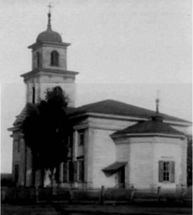
The congregation in Huck was originally part of the Reformed parish headquartered in Norka. A wooden church was built in Huck in 1840.
Today, nothing remains of the Volga German church. There is a new Russian Orthodox church in the village.
The congregation in Huck was served by the following pastors:
Johann Georg Herwig (1769-1782)
Johann Baptista Cattaneo (1784-1831)
Emil Pfeiffer (1927-1934)
|
Year
|
Households
|
Population
|
||
|---|---|---|---|---|
|
Total
|
Male
|
Female
|
||
| 1767 |
|
306
|
|
|
| 1769 |
79
|
319
|
161
|
158
|
| 1773 |
80
|
380
|
195
|
183
|
| 1788 |
78
|
570
|
282
|
288
|
| 1798 |
87
|
643
|
325
|
318
|
| 1816 |
126
|
1,209
|
592
|
617
|
| 1834 |
210
|
2,120
|
1,078
|
1,042
|
| 1850 |
228
|
3,491
|
1,752
|
1,739
|
| 1857 |
372
|
4,241
|
2,110
|
2,131
|
| 1859 |
322
|
4,328
|
2,184
|
2,144
|
| 1886* |
535
|
5,191
|
2,565
|
2,626
|
| 1891 |
400
|
7,384
|
3,688
|
3,696
|
| 1894 |
387
|
7,309
|
3,677
|
3,632
|
| 1897 |
|
5,134**
|
2,521
|
2,613
|
| 1905 |
|
7,200
|
|
|
| 1911 |
|
9,866
|
|
|
| 1920 |
783***
|
6,348
|
|
|
| 1922 |
|
4,938
|
|
|
| 1926**** |
745
|
5,031
|
2,447
|
2,584
|
| 1931 |
|
5,200*****
|
|
|
*Including 172 families that have permanently relocated elsewhere (to daughter colonies on the Wiesenseite, to the Caucasus, and to America).
**Of whom 5,109 were German.
***Of which 762 households were German.
****Of whom 5,014 were German (733 households: 2,431 male & 2,583 female).
*****Of whom 5,188 were German.
Huck (wolgadeutsche.net) in Russian
Huck Village Web Site (Dennis Zitterkopf)
- Beratz, Gottieb. The German colonies on the Lower Volga, their origin and early development: a memorial for the 150th anniversary of the arrival of the first German settlers on the Volga, 29 June 1764. Translated by Adam Giesinger (Lincoln, NE: American Historical Society of Germans from Russia, 1991): 350.
- Diesendorf, V.F. Die Deutschen Russlands : Siedlungen und Siedlungsgebiete : Lexicon. Moscow, 2006.
- Mink, A.N. Historical and Geographical Dictionary of the Saratov Province [in Russian] (Saratov, Russia, 1898): 970-972.
- Pallas, P.S. Reise durch verschiedene Provinzen des Russischen Reichs. Theil 3,2, Reise aus Sibirien zurueck an die Wolga im 1773sten Jahr (St. Petersburg: Kaiserl. Academie der Wissenschaften, 1776): 622.
- Pleve, Igor R. The German Colonies on the Volga: The Second Half of the Eighteenth Century, translated by Richard Rye (Lincoln, NE: American Historical Society of Germans from Russia, 2001): 319.
- Preliminary Results of the Soviet Census of 1926 on the Volga German Autonomous Soviet Socialist Republic (Pokrovsk, 1927): 28-83.
- "Settlements in the 1897 Census." Journal of the American Historical Society of Germans from Russia (Winter, 1990): 19.
51.072833, 45.383833
Migrated From
Immigration Locations

Map showing Huck (1935).

Church in Huck
Source: Steve Schreiber.

School in Huck built in 1890.