Wittmann was founded on 3 August 1767 by colonists who had been recruited by Baron Caneau de Beauregard. However, the first colonists wintered in existing colonies, and relocated to Wittmann in 1768 according to historian Jakob Dietz.
The colony received its name from Ferdinand Wilhelm Wittmann, a soldier, who was the first mayor (Vorsteher) of the colony. By decree on 26 February 1768, the colony was given the official Russian name of Solothurn. It was named after one of the Swiss Kantons in an attempt to create a marketing image that would attract more colonists.
The colony was originally located on the Malenky Karaman (Little Karaman) River, but the soil there was not suitable for farming. In 1770, the colony was relocated to the banks of the Volga River.
In 1915, the Russian name of the colony was changed from Solothurn to Zolotovka. Today, what remains of the former Volga German colony of Wittmann is known as Zolotovka.
The founding colonists of Wittmann were Roman Catholic.
The congregation in Wittmann belonged to the parish headquartered in Schönchen until 1901 when Wittmann became an independent parish with a resident priest of its own. In the earliest years, worship services were held in the prayer house which doubled as the school and church for the colony.
In 1800, a wooden chapel was constructed and consecrated in the name of St. Francis of Assisi. In 1840, a new larger building was constructed. A new church was constructed in the Kontor Style toward the end of the 19th Century. This building functioned as a church until 1931 when it was closed by Soviet officials. The structure burned down in 1933.
The parish in Wittmann was served by the following priests: Florian Schulz (1915-1925)
|
Year
|
Households
|
Population
|
||
|---|---|---|---|---|
|
Total
|
Male
|
Female
|
||
| 1769 |
43
|
128
|
63
|
65
|
| 1773 |
54
|
186
|
93
|
93
|
| 1788 |
51
|
287
|
142
|
145
|
| 1798 |
57
|
340
|
178
|
162
|
| 1816 |
91
|
521
|
264
|
257
|
| 1834 |
122
|
942
|
492
|
450
|
| 1850 |
153
|
1,416
|
717
|
699
|
| 1857 |
168
|
1,635
|
852
|
783
|
| 1859 |
|
1,477
|
|
|
| 1883 |
|
2,311
|
|
|
| 1889 |
|
2,500
|
|
|
| 1894 |
|
|
|
|
| 1897 |
|
2,753*
|
1,385
|
1,368
|
| 1905 |
|
3,500
|
|
|
| 1910 |
|
3,649
|
|
|
| 1912 |
|
4,025
|
|
|
| 1920 |
558
|
3,362
|
|
|
| 1922 |
|
1,972
|
|
|
| 1923 |
|
2,364
|
|
|
| 1926** |
534
|
2,783
|
1,323
|
1,460
|
| 1931 |
|
3,408***
|
|
|
*Of whom 2,736 were German.
**Of whom 2,781 (1,321 male & 1,460 female) were German living in 533 households.
***Of whom 3,406 were German.
Wittmann (Wolgadeutsche.net) in Russian
Wittmann (Solothurn) Russia (Kevin Rupp)
- Beratz, Gottieb. The German colonies on the Lower Volga, their origin and early development: a memorial for the 150th anniversary of the arrival of the first German settlers on the Volga, 29 June 1764. Translated by Adam Giesinger (Lincoln, NE: American Historical Society of Germans from Russia, 1991): 353.
- Diesendorf, V.F. Die Deutschen Russlands : Siedlungen und Siedlungsgebiete : Lexicon. Moscow, 2006.
- Orlov, Gregorii. Report of Conditions of Settlements on the Volga to Catherine II, 14 February 1769.
- Pallas, P.S. Reise durch verschiedene Provinzen des Russischen Reichs. Theil 3,2, Reise aus Sibirien zurueck an die Wolga im 1773sten Jahr (St. Petersburg: Kaiserl. Academie der Wissenschaften, 1776): 614.
- Preliminary Results of the Soviet Census of 1926 on the Volga German Autonomous Soviet Socialist Republic (Pokrovsk, 1927): 28-83.
- "Settlements in the 1897 Census." Journal of the American Historical Society of Germans from Russia (Winter, 1990): 16.
51.890064, 47.156874
Migrated From
Immigration Locations
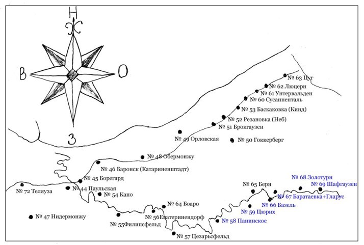
Map redrawn from one that was created in 1764. It shows the original location planned for the colony of Wittmann (No. 68) on the banks of the Malenkiy Karaman (Little Karaman) River.
Source: Andreas Reith.

Map showing Wittmann on the left (1935).

Wittmann Catholic Church and Bell Tower.
Source: Heimatbuch der Deutschen aus Rußland, 1972.