Dinkel was founded on 12 May 1767 by 56 families of colonists recruited by LeRoi & Pictet from Holstein, Württemberg, and Mecklenburg. It was located on the left bank of the Tarlyk River at the point where it enters the Volga River. It was named after Johann Wilhelm Dinkel, the first leader of the colony.
Dinkel was one of the Volga German colonies that was plundered by the Pugachev raiders in 1774.
During the 1921 Famine, 238 people died in Dinkel.
Today, what remains of the former Volga German colony of Dinkel is known as Tarlykovka.
The congregation in Dinkel was part of the Warenburg Lutheran Parish which had been established in 1770. The congregations of Dinkel & Laub left the Warenburg Parish in 1909 and formed a new parish called the Tarlyk Parish.
During the first decades, the congregation in Warenburg held worship services in a Bethaus (combination church and school building). The first church, built of wood, was constructed in Warenburg in 1807.
With a 50,000 ruble bequest from the estate of one of the Müller family members, construction began on a new church building in Dinkel in 1891 in the neo-Gothic style. It was consecrated in 1894. A new organ built by the E. F. Walcker Organ Company in Germany was installed in the Dinkel parish in 1898. This organ has often been attributed to the Warenburg Church, but the pastoral chronicles of the Warenburg Parish researched by Richard Kissling reveal that it was installed in the Dinkel parish in 1898 (not 1889).
By a decree of the Presidium of the Central Executive Committee of the Autonomous Soviet Socialist Republic of the Volga Germans on 14 May 1938, the church in the village of Dinkel was closed. At that time, there were still 595 members registered with the parish.
Today, nothing remains of the church in the former colony of Dinkel.
The congregation in Dinkel was served by the following pastors:
- 1785-1788 Friedrich Konrad Strengel
- 1797-1825 Bernhard Wilhelm Litfass
|
Year
|
Households
|
Population
|
||
|---|---|---|---|---|
|
Total
|
Male
|
Female
|
||
| 1767 |
56
|
166
|
|
|
| 1769 |
52
|
173
|
91
|
82
|
| 1773 |
47
|
179
|
90
|
89
|
| 1788 |
42
|
187
|
89
|
98
|
| 1798 |
51
|
271
|
128
|
141
|
| 1816 |
54
|
333
|
170
|
163
|
| 1834 |
74
|
585
|
290
|
295
|
| 1850 |
119
|
900
|
458
|
442
|
| 1857 |
113
|
1,043
|
526
|
517
|
| 1859 |
115
|
1,132
|
588
|
544
|
| 1871 |
|
1,565 |
|
|
| 1883 |
|
1,917
|
|
|
| 1888 |
334
|
1,949
|
1,004
|
945
|
| 1897 |
|
1,703*
|
862
|
841
|
| 1904 |
|
2,889
|
|
|
| 1910 |
302
|
3,224
|
1,594
|
1,630
|
| 1912 |
|
3,586
|
|
|
| 1920 |
356
|
2,564
|
|
|
| 1922 |
|
1,709
|
|
|
| 1926 |
315
|
1,592**
|
714
|
878
|
| 1931 |
|
1,864***
|
|
|
*Of whom 1,669 were German.
**Of whom 1,585 were German (311 households: 708 male & 877 female).
***Of whom 1,850 were German.
- Dinkel (wolgadeutsche.net) [in Russian]
- Beratz, Gottieb. The German colonies on the Lower Volga, their origin and early development: a memorial for the 150th anniversary of the arrival of the first German settlers on the Volga, 29 June 1764. Translated by Adam Giesinger (Lincoln, NE: American Historical Society of Germans from Russia, 1991): 349.
- Diesendorf, V.F. Die Deutschen Russlands : Siedlungen und Siedlungsgebiete : Lexicon. Moscow, 2006.
- Orlov, Gregorii. Report of Conditions of Settlements on the Volga to Catherine II, 14 February 1769.
- Pallas, P.S. Reise durch verschiedene Provinzen des Russischen Reichs. Theil 3,2, Reise aus Sibirien zurueck an die Wolga im 1773sten Jahr (St. Petersburg: Kaiserl. Academie der Wissenschaften, 1776): 609.
- Pleve, Igor. Einwanderung in das Wolgagebiet, 1764-1767 Band 1 (Göttingen: Der Göttinger Arbeitskreis, 1999): 297-311.
- Pleve, Igor R. The German Colonies on the Volga: The Second Half of the Eighteenth Century, translated by Richard Rye (Lincoln, NE: American Historical Society of Germans from Russia, 2001): 319.
- Preliminary Results of the Soviet Census of 1926 on the Volga German Autonomous Soviet Socialist Republic (Pokrovsk, 1927): 28-83.
- "Settlements in the 1897 Census." Journal of the American Historical Society of Germans from Russia (Winter, 1990): 17.
51.025167, 46.093167
Migrated From
Immigration Locations

Map showing Dinkel - on the right (1935).
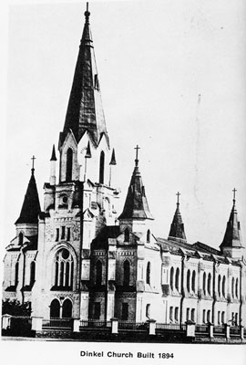
Dinkel Lutheran Church built in 1894.
Source: Heimatbuch.

Church in Dinkel.
Source: Jorge Bohn.

School in Dinkel.
Source: Heimatbuch.
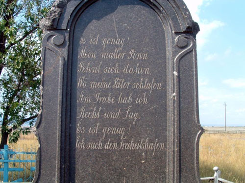
Back of Jacob Wilhelm Müller's tombstone at the cemetery in Dinkel. The front and back of the granite tombstone are of Jacob Wilhelm Müller. Jacob was born January 31, 1799 and died 1883.
Source: Sharon While (August 2003).

Hand-drawn map of Dinkel.
Source: Sharon White.
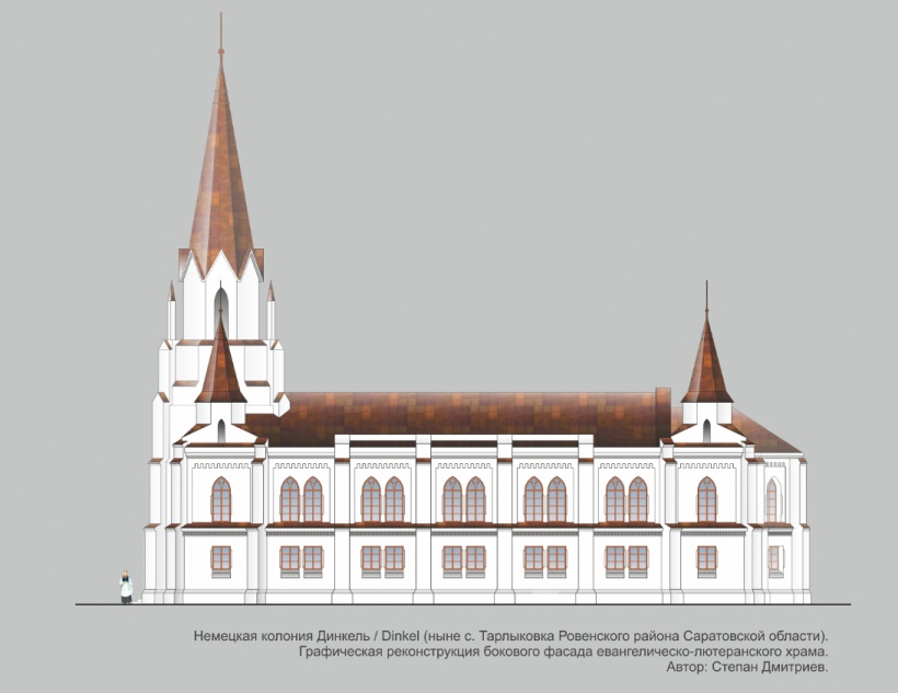
Sketch of the church in Dinkel.
Source: Stephan Dmitriev via Wolgadeutsche.net.