Orlovskaya was founded on 7 June 1767 by Baron Caneau de Beauregard as a Lutheran colony.
Today, what remains of the colony of Orlovskaya is known as Orlovskoye.
Orlovskaya was originally part of the parish headquartered in Katharinenstadt. In 1820, it became part of the parish headquartered in Näb.
A new Lutheran church was built in Orlovskaya in 1860 by architect Frederick Lagus. During the Soviet era, the building was used as a granary and warehouse - the same fate of many Volga German churches. In 1960, the bell tower was removed. Following a fire in 1969, the building was rebuilt and now houses a community center and the village library.
|
Year
|
Households
|
Population
|
||
|---|---|---|---|---|
|
Total
|
Male
|
Female
|
||
| 1767 |
87
|
284
|
151
|
133
|
| 1769 |
90
|
312
|
168
|
144
|
| 1773 |
82
|
322
|
179
|
143
|
| 1788 |
72
|
344
|
188
|
156
|
| 1798 |
74
|
415
|
219
|
196
|
| 1816 |
104
|
791
|
398
|
393
|
| 1834 |
175
|
1,302
|
674
|
628
|
| 1850 |
238
|
1,769
|
892
|
877
|
| 1857 |
211
|
2,217
|
1,101
|
1,116
|
| 1859 |
199
|
2,376
|
1,181
|
1,195
|
| 1886 |
|
|
|
|
| 1891 |
|
|
|
|
| 1894 |
|
|
|
|
| 1897 |
|
3,775*
|
1,891
|
1,884
|
| 1904 |
|
|
|
|
| 1910 |
537
|
6,192
|
3,082
|
3,110
|
| 1912 |
|
6,517
|
|
|
| 1920 |
600
|
4,370
|
|
|
| 1926** |
526
|
2,759
|
1,297
|
1,462
|
*Of whom 3,768 were German.
**Of those, 2,709 (1,265 male & 1,444 female) were German living in 521 households.
Orlovskaya (Wolgadeutsche.net) in Russian
- Beratz, Gottieb. The German colonies on the Lower Volga, their origin and early development: a memorial for the 150th anniversary of the arrival of the first German settlers on the Volga, 29 June 1764. Translated by Adam Giesinger (Lincoln, NE: American Historical Society of Germans from Russia, 1991): 352.
- Diesendorf, V.F. Die Deutschen Russlands : Siedlungen und Siedlungsgebiete : Lexicon. Moscow, 2006.Pallas, P.S. Reise durch verschiedene Provinzen des Russischen Reichs. Theil 3,2, Reise aus Sibirien zurueck an die Wolga im 1773sten Jahr (St. Petersburg: Kaiserl. Academie der Wissenschaften, 1776): 613.
- Preliminary Results of the Soviet Census of 1926 on the Volga German Autonomous Soviet Socialist Republic (Pokrovsk, 1927): 28-83.
- "Settlements in the 1897 Census." Journal of the American Historical Society of Germans from Russia (Winter, 1990): 17.
- 1767 Census of Orlovskaya (Altenhoff.org)
- 1798 Census of Orlovskaya (Altenhoff.org)
- 1834 Census of Orlovskaya (Altenhoff.org)
51.761667, 46.8995
Migrated From
Immigration Locations

Map showing Orlovskaya (1935).
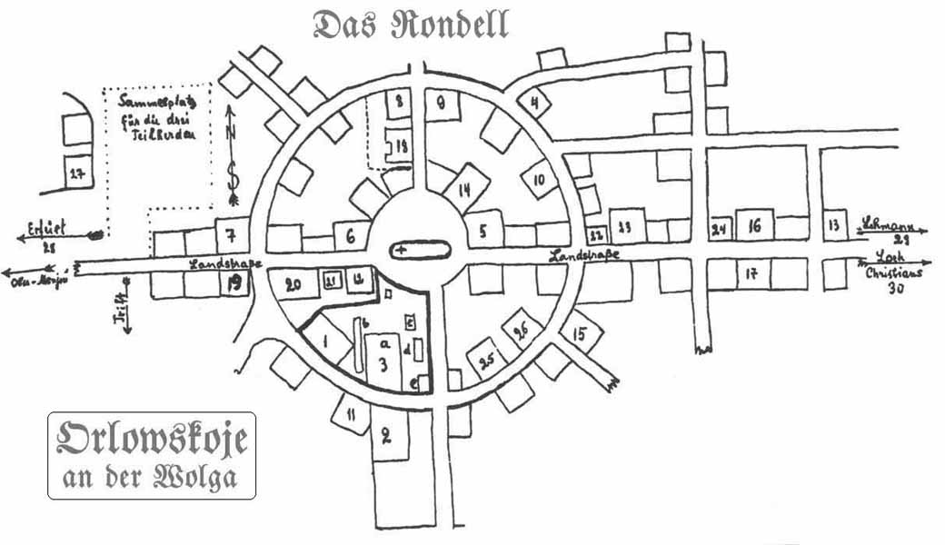
Map of Orlovskaya.
Originally posted to Wolgadeutsche.net
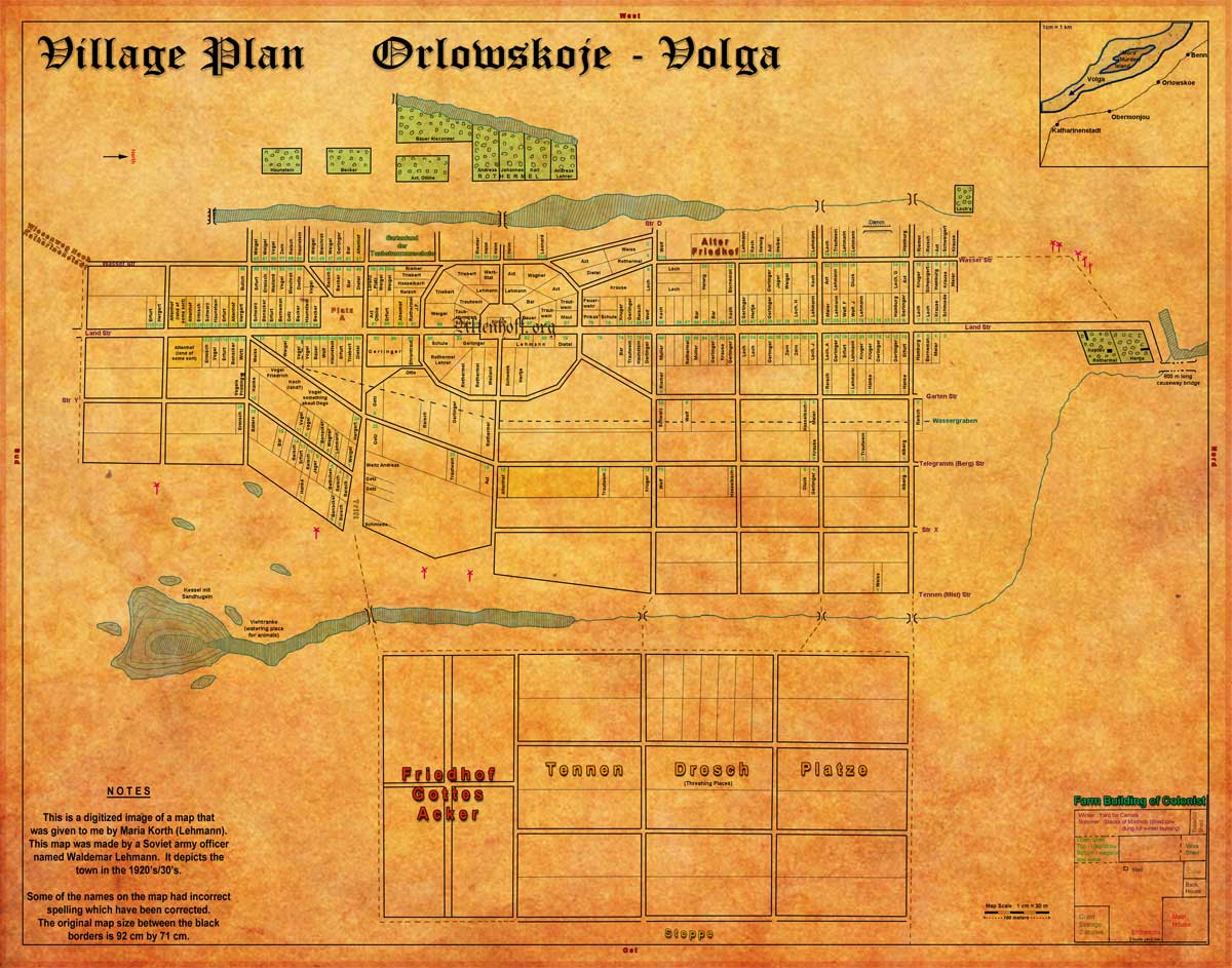
Map of Orlovskaya.
Source: Nataliya Malinovskaya.

Orlovskaya Central School circa 1930.

Orlovskaya's former school,
currently a shop is located on the first floor.
Photo (2007) courtesy of Valeri Taboyakov and originally posted to Wolgadeutsche.net.
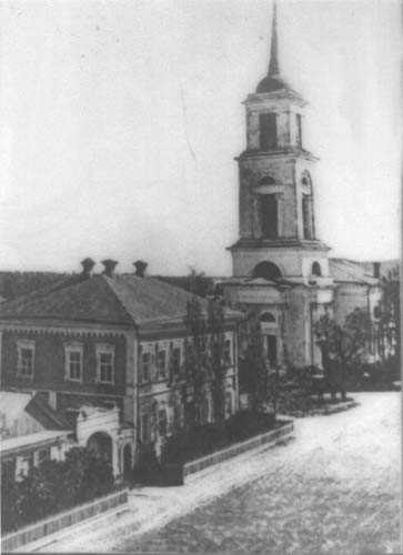
Orlovskaya Lutheran Church built in 1860; photo taken circa 1900.
Source: Wolgadeutsche.net.

Orlovskaya Lutheran Church - now the village library.
Photo (2007) courtesy of Valeri Taboyakov and originally posted to Wolgadeutsche.net.

Not Orlovskaya!
This photograph is mis-identified as Orlovskaya in several sources. It is actually a street scene in the colony of Warenburg.